Brotchie's Steading, Dunnet
01 August 2019
- News Type:
- Site of the Month
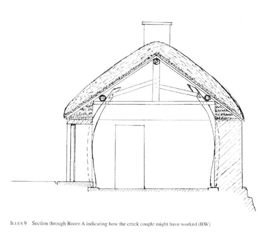
Brotchie’s Steading is a ruined croft house situated just west of Dunnet Church in Caithness, on a platform dropping steeply away on the west side, east of a burn. It is one of several croft houses located on either side of the burn on the 1st Edition OS Map of the area, and it has been used as a steading (and byre) within living memory. It fell into ruin in the second half of the 20th Century, but since the discovery of worked whale jaw bone within the building, later identified as the cruck blades that supported the roof, archaeological investigations have revealed this croft house to have a long history of development, and to be built on an artificial mound that shows evidence of occupation since prehistory.
© Headland Archaeology
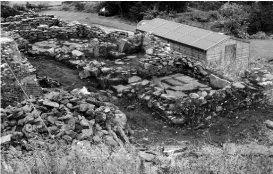
The steading comprises a rectangular building with five compartments and walls standing to no more than 1m in height. Initial excavation work in 2001 was mainly concerned with examining the structure and the role of the whale bone cruck blades within it. The building was cleaned of debris down to the floor surface, which uncovered the most recent structure in plan and allowed an informed reconstruction of the building. The cleaning of the exposed section of walling within the steep slope to the west of the building also revealed 1.5m of intact stratigraphy, and within this, at least four other phases of building. Further trial trenching in 2003 clarified the phasing of the croft house, revealing that in its earliest form, it may have consisted of two separate buildings which were then incorporated into a more typical longhouse structure, with no internal partitions between the living area and assumed byre area, downslope. Subsequent phases saw the building undergoing gradual compartmentalisation (See Illus 6, Holden, 2008 for reconstructed phases). This work had shed much light on the development of a typical croft and that such structures can have undergone much modification in their history of use.
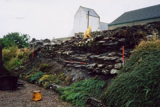
The 2003 work also aimed to assess and characterise the archaeological deposits below the building, consisting of humic sediments 1.5m deep. The croft house itself sat on a flat platform, but the original ground surface sloped downwards to the north and west. At base of the sequence, to the south end of the site, an occupation layer was identified. This contained ash, animal bone, charcoal and fragments of grass tempered pottery, and fragments of sheep bone from this layer were radiocarbon dated to 390-170 cal BC. At the north end of the site, a deeper basal deposit of similar organic sediments was identified. This contained two red deer antler tools with patterns of wear which were radiocarbon dated to 20-230 cal AD. A fragment of cow bone from this layer was also dated to 60-250 cal AD. Above this basal deposit was a thick layer of stone rubble, including fragments of flagstones, which was interpreted as a demolition layer or area of collapse. This appeared to grade into a levelling deposit towards the south of the site. Although there were no features to illustrate the nature of the occupation demonstrated by these deposits, it was clear that there was some form of Iron Age activity going on at the site, with the focus of the settlement, possibly incorporating a substantial stone structure, likely lying beyond the excavation area.
These Iron Age deposits were sealed by a series of organic-rich sediments. These layers were deep, reaching a depth of 0.9m in some places, and covered a wide area. However, with the exception of a heath feature, there were also few structural features associated with these layers. Cereal grains and grass tempered pottery were recovered, and medieval redware fragments were also found in the upper layers. Radiocarbon dates from the cereal grains returned dates of AD 420-620, 550-670, 710-980, 770-980 and 1220-1390. Soil thin section analysis has shown that the layers were likely derived from turf, and therefore could be related to construction for walling and roofing, and reflect repeated construction, demolition and levelling followed by years of reworking by human and biological agents. The resemblance of these deep, extensive organic layers to ‘farm mounds’ identified in areas of Norse settlement in the North Atlantic has also been suggested. Apart from these observations, based on the radiocarbon dates and pottery, little can be concluded from these layers apart from that they accumulated between the 5th-15th centuries, after which at some point the croft house was constructed, on top of what has proved to be part of a very old and extensive archaeological area around the Kirk.
The full extent of the site at Brotchie’s steading is currently unknown and it would benefit from further work. Local tradition describes a broch surviving to the north of the steading, which is based on the investigations of Sir Francis Tress-Barry and John Nicolson, the latter of whom described the remains of the alleged broch and recovery of prehistoric remains from the area in his notes. This does fit with the large quantities of building rubble and Iron Age finds recovered in the earliest levels of the settlement mound. Strong associations between Iron Age settlements and later ecclesiastic sites exist on sites in Orkney and Caithness and since there is good evidence of Iron Age settlement at Brotchie’s Steading and the later medieval deposits also discovered are likely to be contemporary with the earliest Kirk, Brotchie’s Steading may also fall into this category of site. The multi-period environment evidence, pottery and Norse dates too are highly significant as they demonstrate the survival of early and long lived settlement remains below later settlements, including that of Norse and Medieval settlements.
More details of the excavations can be found in the 2003 DSR (available online through the Highland HER) and the 2008 published PSAS article (available online though ADS). See references below.
Further Information
Holden, T. 2002. Brotchie's Steading, Kirkstyle, Dunnet, Highland (Dunnet parish), crofthouse. Discovery Excav Scot, vol. 3, 2002. Pp. 67
Holden, T. 2003b. Brotchie's Steading (Dunnet parish), iron age and medieval settlement; post-medieval farm. Discovery Excav Scot, vol. 4, 2003. Pp. 85-6
HER record MHG46260 and EHG1048
Canmore 241635
See also ARCH Find of the Month August 2019 for a discussion about the whalebone cruck blades.
Submitted by Grace Woolmer
Site of the Month Archive
- 10/04/2021 Easter Raitts township
- 02/03/2021 Lower Slackbuie, Inverness (ASDA) Neolithic site
- 01/02/2021 Balnuaran of Clava cairns
- 04/01/2021 Wilkhouse Inn
- 02/12/2020 Spinningdale Cotton Mill
- 02/11/2020 Skibo A Canadian Forestry Camp
- 01/10/2020 WWI Detonator Store, Dalmore near Invergordon
- 03/09/2020 Mesolithic Shell Midden at Sand, Wester Ross
- 08/08/2020 Kinbeachie Neolithic settlement
- 01/07/2020 Armadale Cist Burial and Stone & Timber Complex