
Rubh' an Dunain Canal and Harbour
01 December 2019
- News Type:
- Site of the Month
courtesty Highland HER
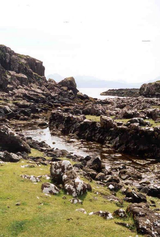
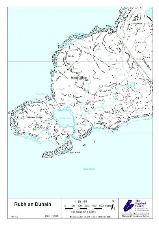
The peninsula of the Rubh’ an Dùnain, located on the southern tip of Skye, is by today’s standards a remote area, bounded on three side by the sea and mountains on the other. However, when sea was the primary means of transport, this area would have been a focal point in a much larger network across the western seaboard of Scotland. Contained across the peninsula is evidence of occupation stretching as far back as the Mesolithic and continuing up until the 19th century. One of the elements which seem to have made it such an important area is its maritime significance; located very close to the seaward end is a shallow fresh water loch (Loch na h-Airde). Between this and a natural creek on the coastline is a naturally gully and channel which has been recognised to have undergone modification and different phases of use over time. The siting of a cliff-top dun on a promontory which dominates and fortifies the seaward approach indicates that this may have begun in the Iron Age.
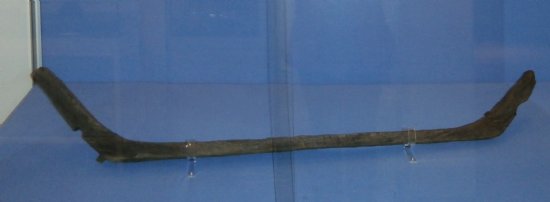
Armadale. Photo © Museum of the Isles
Investigations of the loch, channel and surrounding features began in the 1980s. Survey and underwater searches of the loch have been undertaken in which waterlogged wooden objects were noted. In 2000, a boat timber of oak was recovered during exceptionally low water levels within the loch. Analysis has suggested that it was from a clinker-built vessel, and radiocarbon dated to c. AD 1100 (see Find of the Month, December 2019). In light of this, a programme of intensive non-intrusive survey of the loch and adjacent features was undertaken, starting in 2009. The primary aim of this project was to obtain as full an understanding as possible of the site and its potential for future research. The work was very successful, revealing a sequence of maritime features including two docks with nousts, a canal, two lochside quays and possible associated buildings. The purpose of this complex was clearly associated with the management and maintenance of watercraft; with Loch na h-Airde small and shallow and leading nowhere apart from the sea, activities must have related to over-wintering, maintenance or perhaps boatbuilding on the loch’s shores. This purpose later changed however, when the canal was at some point substantially blocked.
The only dates that could be indirectly associated with the complex were from the Iron Age dun, and Norse/Medieval boat fragment. Nonetheless, it was still possible to construct a relative chronology for the features. The first phase was the construction on the dun during the Iron Age on the promontory, and many factors appear to have conditioned this site’s selection. Chief of these are the extensive views from the promontory across to Skye, the Small Isles and the mainland, and the proximity to the natural gully along which vessels could be floated up and secured on the natural and sheltered landing area beneath the landward end of the headland, on which the dun is built on top of (see figure 7 of the DSR). The boat access along this gully was also at some point improved by stone clearance and some revetment, and the landing and drawing up ground behind the promontory also enhanced by the building of stone lined docks and nousts, providing facilities for loading, unloading and minor maintenance. While there is no evidence for the dun, docks and nousts being contemporary, their proximity and the ease of access between them makes it unlikely to be merely coincidental.
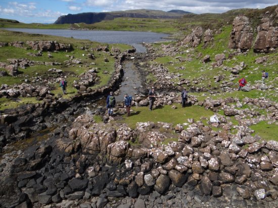
The second clear phase was the extension of the access channel from the docks to the loch. This was achieved by the creation of a stone lined canal, 3.5m wide and 0.6m deep, which followed the original watercourse between two rocky outcrops, and opened the loch to ingress by the sea. Both sides of the canal were revetted and the beginning of this canal extension could be clearly seen starting from opposite one of the docks; the horizontal laid stonework of the earlier boat access channel is juxtaposed against the random rubble build of smaller boulders characterising the later canal revetment. Substantial quays either side of the canal entrance into the loch were also built, and although these are now below the surface of the loch, the upper part likely having been robbed, they are still clearly visible.
At some point after the construction of the canal, two other phases along its upper part were recognized. Firstly, the eastern wall of the canal was largely demolished, with the stones cast onto the adjacent bank. The purpose of this could perhaps have been to allow larger vessel access along the canal and into the loch. Due to the fact that no revetment was built along this new line, this may have been in response to some unexpected crisis. It is likely to have represented the final modification to the system, since the canal was also blocked half way along its length at some point, preventing vessels from being floated into the loch anymore. Due to the tumbled state of the blockage, which obscured any structural elements, little more can be interpreted from it beyond its effect of maintaining the loch at a relatively constant level, and providing a causeway, possibly for people and animals to move across.
The foundations of several buildings were also recorded either side of the channel. Some overlay each other and other features, such as the banks of the docks, but apart from this, their date and phasing in unknown. The dun was also recorded to have undergone modification and repair, and the substantial nature of the building and its dominance in the landscape make it likely to have been reused in some way during the early medieval and later periods. Rubh’ an Dùnain has traditionally been part of the lands belonging to the MacLeods of Dunvegan, and the MacAskills (another clan associated with Rubh’ an Dùnain in the later Medieval period and who also had Norse antecedents) moved to the area as coastguards for them; there are traditional accounts of them using the dun as a strong point, lookout and beacon stance within a wider network.
There are no direct comparisons for this site in Scotland and it is therefore of national significance. This is reflected in it achieving scheduled status in 2017. The non-intrusive survey work has produced a remarkable new understanding of the site and despite the limited dating evidence, the phasing and development of the sequence of structures is reasonably secure, possible starting in the Iron Age, and certainly in operation in Norse/Medieval period. The well planned and well executed programme of works produced a number of recommendations for future work, and these will certainly elucidate the chronological relationships between the features. With further carefully planned, targeted and skilled work, this is a site which promises to shed light on multiple periods of the past, locally, regionally and, in light of the uniqueness of the site, nationally.
Further Information
Martin, C. 2009. Rubh' an Dunain, Bracadale, Skye: Data Structure Report. Morvern Maritime Centre. (Available through HER record)
Martin, C. & Martin, P. 2018. Rubh' an Dunain: a multi-period maritime landscape on the Isle of Skye, Inner Hebrides, Scotland. The International Journal of Nautical Archaeology. Vol. 47, Issue 1: 140-158 (Available with subscription)
Links
https://her.highland.gov.uk/Monument/MHG4895
https://canmore.org.uk/site/11028
http://portal.historicenvironment.scot/designation/SM13676
https://nosasblog.wordpress.com/2015/06/23/rubh-an-dunain-skye-8000-years-of-history/
Report contributed by Grace Woolmer
Site of the Month Archive
- 10/04/2021 Easter Raitts township
- 02/03/2021 Lower Slackbuie, Inverness (ASDA) Neolithic site
- 01/02/2021 Balnuaran of Clava cairns
- 04/01/2021 Wilkhouse Inn
- 02/12/2020 Spinningdale Cotton Mill
- 02/11/2020 Skibo A Canadian Forestry Camp
- 01/10/2020 WWI Detonator Store, Dalmore near Invergordon
- 03/09/2020 Mesolithic Shell Midden at Sand, Wester Ross
- 08/08/2020 Kinbeachie Neolithic settlement
- 01/07/2020 Armadale Cist Burial and Stone & Timber Complex